Mabgate
Coordinates: 53°48′07″N 1°31′52″W / 53.802°N 1.531°W

Mabgate is an inner city area of Leeds, West Yorkshire, England, and the name of one of the streets in it. "The area is bounded to the west by North Street; to the east by Macaulay Street; to the north by Mushroom Street and to the south by the New York Road." [1] However, the street itself continues a little way on the south side of the New York Road (A64(M)). The area lies within the Burmantofts and Richmond Hill ward of the Leeds Metropolitan Council.
The name comes from 'Mab', meaning a prostitute (16th to 19th century) and 'gate' meaning a street (common in Yorkshire street names).[2][3][4]
It started at the end of the 18th century as a series of woollen mills along the Lady Beck or Mabgate Beck which runs parallel to the Mabgate on the west, and by 1850 had become a dense area of industry and workers' houses.[1] On the other side of the stream is the street called Mabgate Green. The area contains four listed buildings: The Hope Foundry, Mabgate; Hope House, Mabgate; Smithfield Hotel, North Street; and Crispin House, New York Road.[1] The Black Horse public house is on the site of Mabgate Hall (1673) then the Black Bull Inn, being rebuilt in 1868 as the Black Horse.[5] The City of Mabgate Inn (on Mabgate) was converted to flats in 2006. It dates from 1857: the green area opposite was a cholera burial ground.[6]
-

The Hope Buildings
-

The Hope Foundry
-

The Black Horse pub, Mabgate
-

City of Mabgate Inn
-
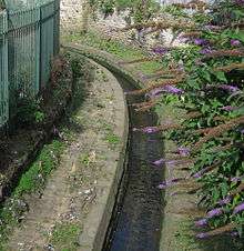
Lady Beck
References
- 1 2 3 Leeds City Council (2007) Mabgate Development Framework
- ↑ A. H. Smith (1961) The Place-Names of the West Riding of Yorkshire, Part IV Cambridge University Press
- ↑ Oxford English Dictionary
- ↑ Yorkshire Evening Post 2 October 2012 "Leeds funny place names"
- ↑ www.leodis.net Black Horse, Mabgate
- ↑ www.leodis.net City of Mabgate Inn.
Location grid
 |
Harehills | | ||
| Sheepscar, Little London | |
Lincoln Green | ||
| ||||
| | ||||
| city centre, Quarry Hill |